
Wetlands
by Richard D. Porcher and Douglas A. Rayner*
adapted from A Guide to the Wildflowers of South Carolina. Used by permission.
Marshes, swamps, peatlands, bogs, and fens are wetlands. No single, accepted term in the scientific community defines a wetland. In general terms, however, wetlands are lands where saturation with water is the dominant factor determining the nature of soil development and the types of plant and animal communities living in the soil and on its surface.
Marshes
Marshes are wetlands that are inhabited by herbaceous plants that have their roots in the substrate but with their photosynthetic and reproductive organs principally emerged. Marshes have predominantly mineral (nonorganic) soils, even though much organic material may be incorporated. The dominant species are grasses, rushes, and sedges along with numerous broadleaf flowering plants. Marshes in South Carolina can be classified as salt, brackish, or fresh water.
Salt marshes generally occur on a peaty substrate along tidal inlets, behind barrier islands, and on spits along the maritime strand. They are regularly flooded and drained by tidal action. The soil is saturated and has a high salt concentration and low oxygen levels. The most extensive salt marsh community in the coastal area is the Spartina marsh dominated by smooth cordgrass (Spartina alterniflora). Vast stretches of this marsh system are readily visible as one drives from the mainland to the barrier islands, such as Kiawah, Folly, Hilton Head, and Pawleys.
Brackish marshes are transitional communities between the freshwater and saltwater marshes. They occur in the outer coastal plain where fresh water and salt water mix, so species of both systems occur here. The dominant species are emergent grasses, sedges, and rushes. The brackish marshes occur at varying distances up rivers from the coast. The more fresh water coming down the rivers, the closer the brackish zone occurs to the coast.
Freshwater marshes occur both inland and along the coastal rivers. Inland freshwater marshes occur throughout the state and are a diverse system fed by inflowing water, seepage, or precipitation. The variable water supply results in flooding during high rainfall and drawdown during dry periods, a feature that shapes the structure and composition of the marsh. Inland marshes occur along the edges of lakes and ponds, in canals and roadside ditches, and along the edge of inland swamps.
The dominant freshwater marshes of the state, however, are the tidal freshwater marshes of the outer coastal plain. These marshes occur along the edge of the brownwater and blackwater rivers and are close enough to be affected by daily freshwater tides but far enough to be unaffected by the intrusion of salt water. Vast expanses of these marshes occur in the abandoned rice fields along rivers. Narrow zones of freshwater marsh also occur where the tidal swamps border the rivers. The low marsh, with its deeper water, is characterized by broadleaf monocots such as arrow arum and pickerelweed and showy dicots such as bur-marigold. The high marsh is a mixture of low marsh species plus numerous grasses, rushes, and sedges.
Swamps
Woody plants dominate swamp wetlands. The substrate in swamps is flooded for one or more extended periods during each year. Sometimes the flooding is more or less permanent, but usually a swamp is without surface water for at least part of the year. Although much organic material may be incorporated in the soil, swamps have predominantly mineral (nonorganic) soils, South Carolina's swamps are extensive and varied and include the alluvial bottomland swamps (i.e., swamps associated with streams and rivers), tidal freshwater swamps, and nonalluvial swamps.
Bottomland swamps occur on the alluvial floodplains of the brownwater rivers of the lower piedmont and coastal plain, and on the blackwater rivers of the coastal plain. Brownwater rivers originate in the mountains and piedmont and have wide alluvial floodplains, while the blackwater rivers originate in the coastal plain and have narrower, less-developed alluvial floodplains. On the regions of the floodplain where the land is almost continually flooded, bald cypress-tupelo gum swamps occur. Here the trees exhibit typical hydromorphic features in response to growing in water: buttresses, knees (in bald cypress), and spongy roots. Hardwood bottoms occur in the coastal plain and piedmont on floodplains that are slightly elevated above the adjoining swamp forests. Here the land is often flooded, but it is dry through much of the year. The dominant vegetation is a mix of water-tolerant, deciduous hardwoods, with oaks predominating and an occasional cypress from the adjacent swamp forests also occurring.
Tidal freshwater swamps occur in the outer coastal plain, from the upper limit of tidal influence to the brackish water line downstream. Tidal freshwater swamps owe their nature to the river tides. Twice a day they are flooded and twice a day they are free of surface water. Both brownwater and blackwater rivers support tidal swamp forests. Tidal freshwater swamps today are mainly secondary swamps. The original tidal swamps were cleared to make rice fields. The fields were abandoned in the early 1900s, and today secondary tidal swamps are gradually reclaiming the fields. The tidal swamps are similar in composition to the alluvial swamps.
A variety of nonalluvial swamps occur in the state. The main feature distinguishing these swamps is that they are not associated with moving river water. In other words, they are not alluvial or tidal systems. These swamps occur in two types of habitats: (1) upland, isolated sites such as lime sinks, Carolina bays, and irregular depressions, and (2) seepage slopes (see below) associated with river systems along the boundary of floodplains and uplands. The water supply for the bays, sinks, irregular depressions, and seepage slopes is predominately rainwater. One example of an upland, nonalluvial swamp that is covered in this book is the pond cypress swamp gum upland swamp.
Peatlands
Peatlands are simply wetlands whose soils are peat, the partially decomposed remains of dead plants. The dominant peatlands in the state are the pocosins or evergreen shrub bogs. Pocosins are freshwater wetlands found extensively in the outer coastal plain of Virginia, North Carolina, South Carolina, and Georgia. They are fire-adapted systems dominated by a tangled mass of broadleaf evergreen or semievergreen shrubs and vines, with scattered pond pines and occasional bay trees (swamp red bay, sweet bay and loblolly bay). The most extensive pocosins are found on flat upland areas. Additionally, pocosins may be found in Carolina bays, wet seepage slopes, and in low areas of relict dune fields.
Another type of pocosin is the streamhead pocosin, which is found primarily in the sandhills. They occur along the headwaters of small streams, streamside flats, and extend up adjacent hillsides. This community is most common in the fall-line sandhills, but it does occur in the inner coastal plain.
Bogs
Bogs are ombrotrophic (mineral-poor) wetlands because they receive their water from rain, which contains few minerals. The only true bogs in South Carolina are the sphagnum openings in pocosins. Periodic fires create these openings in the shrub layer where sphagnum develops. If the openings are removed far enough from the boundary of the pocosin and adjacent upland so that they receive no seepage, only rainwater, they are true bogs.
Fens
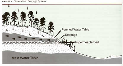
Fens are wetlands that harbor an open, herb-dominated community, and receive water from rain and from seepage. Seepages are not plant communities per se. Seepage refers to a water source, which can allow wetland communities like a fen to develop. Seepage occurs when rainwater penetrates the soil to an impermeable layer (such as a clay hardpan). The water then moves laterally through the soil over this impermeable layer. Where the soil slopes so that the impermeable layer is exposed at the surface (outcrops), water seeps out of the soil and flows down the slope. The water picks up dissolved minerals from the soil, which contribute to the mineral supply of the seepage. Figure 8 illustrates a generalized seepage system.
If the seepage water feeding a fen is mineral-poor, it is a poor fen. Often, however, the water seeps through limestone or mafic rock and picks up minerals. These are rich fens because of the high mineral content.
In the section, “South Carolina's natural wildflower communities” [in A Guide to the Wildflowers of South Carolina], two mountain communities are discussed, the montane bog and the cataract bog. These two communities are not bogs, as defined above, but fens. Their main source of water is seepage, not rainwater. However, the term bog has been used for so long for these communities that we retain this common usage and refer to them as bogs. The reader is now aware of their true nature — that is, they are fens.
* Dr. Porcher is professor emeritus and former director of the herbarium at The Citadel in Charleston, and Dr. Rayner is a professor of biology at Wofford College in Spartanburg. Together they are the authors of A Guide to the Wildflowers of South Carolina.
Links to:
How Plants Grow: A Simple Introduction to Structural Botany by Asa Gray
Habit Terms
Plant Morphology Terms
- Leaves & Leaves
- Twigs
- Bark
- Flowers & Flowers
- Fruit & Fruit and Seed
- General Terms
- Ferns
- Grasses' principal parts
- Grasses: cool-season turfgrass ID
- Palms & Palmettos glossary
- Palms & Palmettos pictorial glossary
Natural Communities
- The Blue Ridge
- North Carolina (PDF)
- South Carolina (PDF)
- SC's Wildflower Communities
- The Southeast Mountains
- Wetlands
Other glossaries...
From Wayne's Word, an online textbook of natural history
- Flower Terminology #1
- Flower Terminology #2
- Flower Terminology #3
- Inflorescence Terminology #1
- Inflorescence Terminology #2
- Leaf Terminology #1
- Leaf Terminology #2
- Fruit Terminology #1
- Fruit Terminology #2
- Fruit Terminology #3
- Fruit Terminology #4
From vPlants: a Virtual Herbarium of the Chicago Region
From Vascular Plant Systematics, by Radford, Dickison, Massey, and Bell
From the Plant Information Center at UNC, Chapel Hill
From the Native Plant Trust GoBotany project
From the Virginia Department of Conservation and Recreation
From the Northern Ontario Plant Database
From the Digital Atlas of Ancient Life
From the Australian Pea-flowered Legume Research Group
From (?)