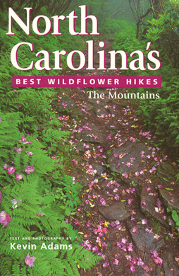
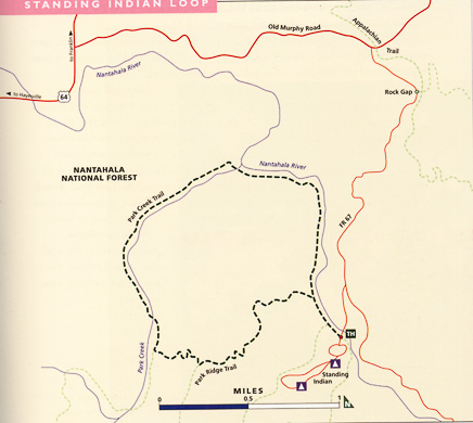
Standing Indian Loop
in the Nantahala National Forest
by Kevin Adams*
Reprinted from North Carolina's Best Wildflower Hikes: The Mountains, and used by permission.
Highlight: Good variety of spring wildflowers
Trail Rating: Moderate
Trail Length: 5.3 miles round-trip
Location: Nantahala National Forest
Elevation: 3,400-3,890 feet
Contact: Wayah Ranger District; Nantahala NF, 828-524-6441
Bloom Season: Mid-March to September
Peak Bloom: Last half of April
Directions: From US 441/23 in Franklin, drive 11.7 miles west on US 64 and turn left on Old Murphy Road at the sign for Standing Indian Campground. Proceed 1.9 miles and turn right onto FR 67. After 1.7 miles the road forks. Take the right fork into the campground and turn left into the day-use parking area after 0.1 mile.
The Standing Indian region of Nantahala National Forest is popular with hikers, equestrians, trout fishers, and car campers. The loop hike outlined here uses some of the lesser-traveled trails, so you can expect to have much of this hike to yourself. However, plan on some company along the first section that closely parallels Nantahala River.
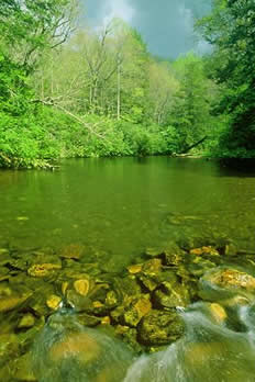
Nantahala River (Kevin Adams)
Begin the hike by walking on the paved road toward the camping area (away from the camp store) and crossing over Nantahala River. On the other side of the bridge, look for the trail turning right and heading downstream. The trail passes through dense rosebay rhododendron, some of the largest I’ve seen, and soon comes to a junction with Kimsey Creek Trail, cutting back to the left.
Go to the right and walk alongside Nantahala River on an old logging railroad grade through
thyme-leaved bluet,
Robbins' ragwort,
common blue violet,
sweet white violet,
and wild geranium.
Just before crossing a small branch at 0.25 mile. Park Ridge Trail turns to the left. You use that trail on the return; for now, continue straight ahead on Park Creek Trail.
After another 0.25 mile you come to a post with two blue blazes (the trail you are on is blue-blazed), marking a rerouted section away from the muddy railroad grade. Go to the left here and pass through several rosebay rhododendron tunnels and patches of wood anemone and painted trillium. At 1.25 mile (0.8 mile after you leave the railroad grade) the trail comes out beside the railroad grade at a small wildflower patch featuring
toothwort,
dwarf ginseng,
foamflower,
Jack-in-the-pulpit,
and both the white and purple color forms of wake robin.
Also growing in the patch is ramps, but you see only the basal leaves in spring.
After a little over 0.1 mile from the wildflower patch, the trail rejoins the old railroad grade and continues downstream to a footbridge over Park Creek, at just under 1.5 miles from the trailhead. Look on the opposite side of the creek for
umbrella leaf,
white wake robin,
large-flowered trillium,
and Canada violet.
The trail picks up another old logging grade that heads upstream alongside Park Creek. The next 1.3 miles follow the blue-blazed trail upstream — kissing the creek in places, hiding from it in others. Except for the final 0.4 mile or so, this segment is virtually a continuous wildflower patch. On my hike I recorded
wild geranium,
buttercup,
both color forms of wake robin,
foamflower,
large-flowered trillium,
May-apple (mostly not yet blooming in April),
brook lettuce,
toothwort,
sharp-lobed hepatica (a few flowers still hanging on in mid-April),
blue cohosh,
showy orchis,
Jack-in-the-pulpit,
great chickweed,
lousewort,
Carolina vetch,
painted trillium,
and the foliage of numerous wildflowers that had either finished flowering or hadn't yet started. Spend some time exploring and there's no telling how many species you'll see.
You have to cross Park Creek at 2.8 miles, which normally is an easy matter, but after heavy rains you might have to wade. After crossing, continue heading upstream and come to the Park Ridge Trail connector on the left after about 250 yards. If the sign is missing and you don't pay attention, you could walk right by the path and not know it. So pay attention.
The mostly easy grade you've been on from the start ends here, and now you begin climbing at a good pace. Fortunately, the ascent is short and the wildflower viewing is great. Look for
painted trillium (common near the start),
wood anemone,
great chickweed,
halberd-leaved violet,
lousewort,
large-flowered trillium,
buttercup,
common blue violet,
showy orchis,
squawroot,
and both color forms of wake robin.
Also, the leafy green foliage of mountain bunchflower is everywhere.
After 0.3 mile of continuous climbing, you come to a grassy road at a gap. The gap is very confusing — old logging roads and trails going everywhere — so spend a little time looking around to make sure you stay on me right trail. There are three grassy roads leading from the gap and at least two weedy, overgrown roads. Park Ridge Trail is obvious where it climbs the steps up the bank, but you don’t want to hike in that direction. Look on the other side of the opening from the steps to find the well-hidden trail. At my visit a small sign here was all but chewed away by animals. Other indicators are a patch of wild strawberry that grows in the grassy road where the trail starts, and a display of Carolina vetch at the beginning of the trail,
The 1.5 miles from the gap back to Park Creek Trail have a more southern exposure, and the forest is noticeably drier. Thus, you see several different wildflower species that are more indicative of this environment, such as
mountain bellwort,
bird’s foot violet,
trailing arbutus (foliage only, the flowers are long gone by mid-April),
squawroot,
and yellow star grass.
At one point the squawroot grows so profusely in the middle of the trail that you can’t help but step on it. The purple-veined basal leaves of rattlesnake weed are prominent, but the yellow flowers usually don’t appear until May.
At a few locations the trail swings briefly onto north-facing slopes that have large-flowered trillium, baneberry, and mountain bunchflower foliage. A few large-flowered trillium grow scattered on the drier slopes, but not much.
The trail picks up a small drainage and crosses the branch a few times through dense rosebay rhododendron before finally reaching the trail junction. This final stretch through the rhododendron is a good place to look for painted trillium.
Turn right at the trail junction and retrace the route to the parking area.
* Acclaimed photographer and North Carolina native Kevin Adams is the author of North Carolina Waterfalls, Wildflowers of the Southern Appalachians (with coauthor Marty Casstevens), Waterfalls of Virginia and West Virginia, Hiking Great Smoky Mountains National Park, Our North Carolina, North Carolina Then & Now, Backroads of North Carolina, and North Carolina's Best Wildflower Hikes.